Dorian inches closer
Published 10:38 am Thursday, September 5, 2019
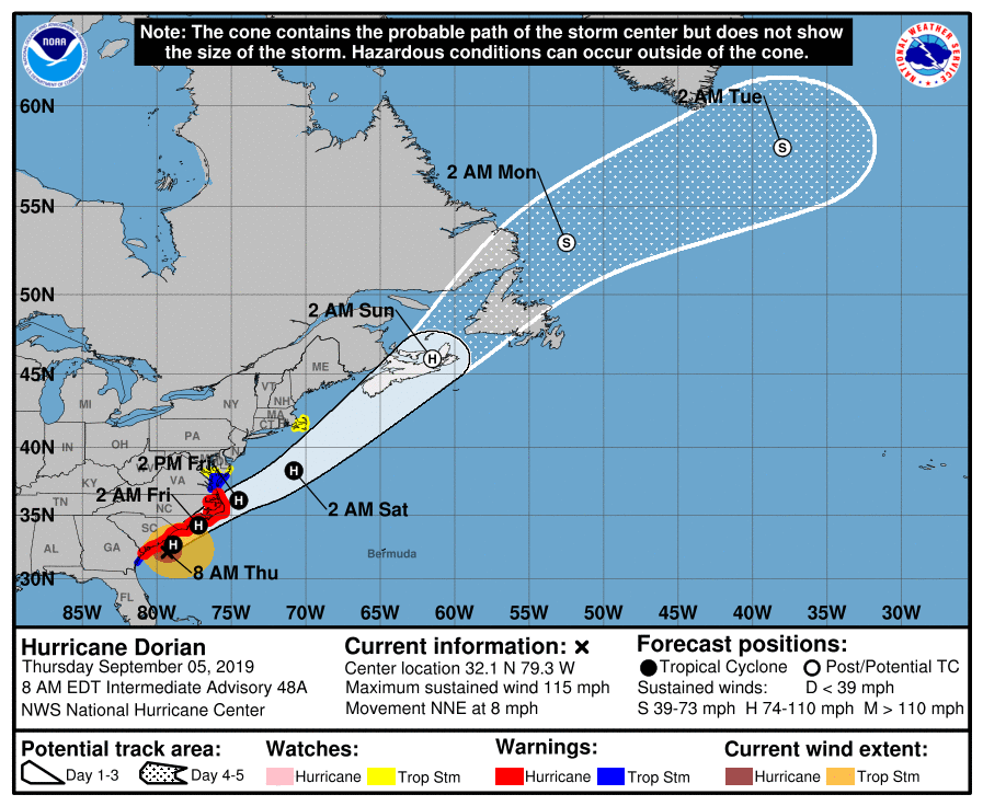
- The National Hurricane Center forecast as of 8 a.m. Thursday shows most of coastal Virginia still under a tropical storm warning. Courtesy | National Hurricane Center
FRANKLIN
As of Thursday’s 11 a.m. update from the National Weather Service, the following warnings are in effect:
A storm surge warning is in effect for the entire East Coast from the Savannah River to Poquoson, the Pamlico and Albemarle Sounds, the Neuse and Pamlico rivers and for all of Hampton Roads. A storm surge warning means there is a danger of life-threatening inundation, from rising water moving inland from the coastline, during the next 36 hours in the indicated locations.
A hurricane warning is in effect on the coast as far north as the Virginia/North Carolina border and for the Pamlico and Albemarle sounds.
A tropical storm warning is in effect from the Virginia/North Carolina border northward to Chincoteague and the Chesapeake Bay from Smith Point Southward. This includes the Western Tidewater region.
Hurricane Dorian is once again a category 2 storm producing maximum sustained winds of 110 miles per hour. Moving to the north-northeast at 8 miles per hour, it is expected to reach the coast of North Carolina late tonight and into early Friday morning, with impacts in Virginia expected throughout Friday. Hurricane-force winds will extend up to 60 miles from the center of the storm, and tropical storm-force winds could extend as for as 195 miles from the center of the storm.
Local impacts
The 8 a.m. NWS forecast update for the city of Franklin and Southampton County is predicting peak winds of 20 to 30 miles per hour, with gusts up to 45 miles per hour. A flash flood watch will begin for both localities, and for Isle of Wight County, at 8 o’clock. tonight and continue through 8 p.m. Friday. Peak rainfall for all three Western Tidewater localities is estimated at three to six inches, with locally higher amounts possible.
Tornadoes are not expected in the Western Tidewater region, though showers and thunderstorms with gusty winds may still occur.
A storm surge warning remains in effect for northern Isle of Wight County. The NWS states that there is potential for a surge of two to four feet above ground within surge-prone areas, beginning early this evening and continuing until early Sunday afternoon.
Peak wind forecast for Isle of Wight is estimated between 25 to 35 miles per hour, with gusts up to 50 miles per hour.