Hurricane Florence increasing in size
Published 2:22 pm Tuesday, September 11, 2018
- Courtesy National Hurricane Center
FRANKLIN
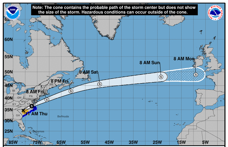
The 2 p.m. bulletin from the National Hurricane Center states that Hurricane Florence is “getting better organized and increasing size.”
The National Weather Service posted that the storm is at 26.7N 65.3W, about 950 miles from Norfolk, and winds holding at 130 mph, which makes it a Category 4 hurricane on the Saffir-Simpson Wind Scale.
The NWS on its website gave the following overview:
Hurricane Florence has intensified into a dangerous category 4 hurricane, and is expected to make landfall as a major hurricane in North Carolina or northern South Carolina early Friday morning. While the exact track of Florence remains uncertain, significant to potentially life threatening impacts are expected across portions of northeast North Carolina. A slight shift in the track could change impacts drastically.
Significant and potentially life-threatening storm surge impacts are expected with Hurricane Florence. Based on the current forecast, inundation of 3 to 6 feet above ground level is expected over areas along the coast and near the Albemarle Sound. A small shift in the track could change which locations experience the most significant inundation.
Hurricane force winds in excess of 74 mph will be possible with the strongest winds from late Thursday night through Friday afternoon. Tropical storm force winds of 40 mph could develop as early as Thursday morning. These strong winds will have the ability to knock down trees, weak structures, and cause widespread power outages.
Another life-threatening concern as Hurricane Florence makes landfall will be very heavy rainfall leading to the risk for major flooding across northeast North Carolina. The current rainfall forecast indicates widespread amounts of 10 to 15 inches with locally higher amounts possible. These rainfall totals are likely to cause major flooding of low lying and urban areas. Flash flooding is likely to occur Thursday into Saturday, and river flooding from heavy rainfall inland will persist for several days to weeks after the storm. The axis of heaviest rainfall will vary with changes to the forecast track and storm motion. Isolated tornadoes will be also be possible Thursday and Friday.
Stay tuned for updates from The Tidewater News on the hurricane and related issues.