LOOKING BACK: Flood devastates Southampton river towns
Published 7:13 pm Wednesday, August 24, 2022
|
Getting your Trinity Audio player ready...
|
By Clyde Parker
Looking Back
On Aug. 23, 1940, Southampton County’s three rivers — Blackwater, Nottoway and Meherrin — which were severely flooded during the previous week, were beginning to recede, leaving total damage conservatively estimated at a million dollars. Several hundred people were driven from their homes or were destitute of food. A health threat — typhoid fever — was present.
The flooding resulted from four successive storms that developed in the tidewater areas of Virginia and eastern North Carolina, caused by an unnamed hurricane that came up through North Carolina and hit the western part of Virginia.
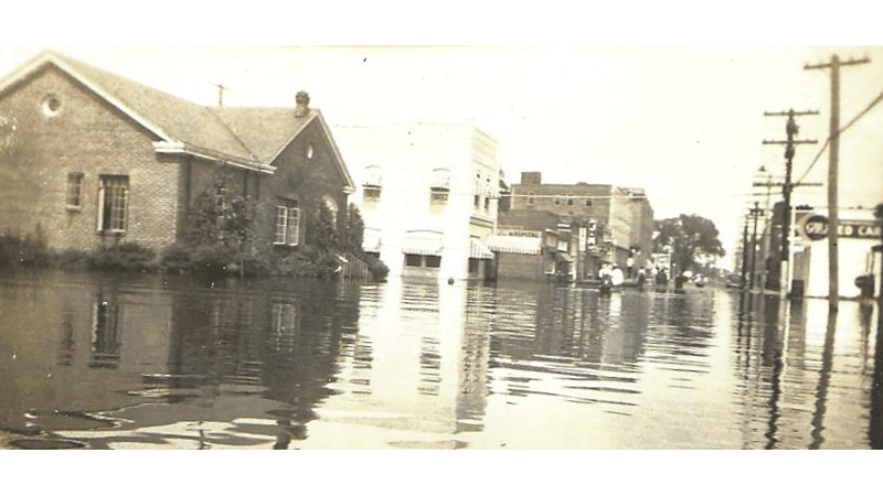
Franklin experienced the worst flood disaster in its history, the Blackwater River rose to the highest level ever recorded, at that time, and wreaked property damage to business firms amounting to $100,000 or more, according to figures compiled by Mrs. Frances Parker Bradford, Secretary of the Franklin Chamber of Commerce. Initially, it was not possible to estimate the residential damage done in Franklin and throughout the county by waters that in some cases covered houses. Many other houses were flooded on lower floors, driving inhabitants to second stories.
Southampton County Farm Agent E. A. Davis thought that $286,000 was a conservative estimate on the damage done to peanuts on hundreds of acres on which water had stood for as much as a week and was draining off slowly. Mr. Davis said the damage to corn and cotton would depend a great deal on the type of weather that would follow when the waters recede. Although considerable loss was felt by farmers along the Blackwater River from Zuni south to Franklin and below, farmers of the Boykins/Branchville district, along the Meherrin River, suffered the greatest damage; many farms in that section were considered to be a total loss – as to producing crops.
Highways began to be blocked on Friday night, Aug. 16, due to flooding. The Nottoway River closed Route 58 just west of Courtland and the Blackwater River closed Route 460 at Zuni. The Blackwater closed the Franklin-Suffolk Highway at Franklin; the two large Camp mills, Camp Manufacturing Co. and Chesapeake-Camp Corp. were cut off from Franklin except by boat. Hygeia Ice Corp. and the American Lumber Co., both just over the bridge from Franklin, were also marooned.
Traffic from Norfolk used the South Quay Road routing to Franklin via Route 189 until late Saturday afternoon, when the Blackwater River cut off that avenue of travel. On Sunday night, the road from Franklin south into North Carolina was closed as the Meherrin River at Murfreesboro made Route 158 impassable. For several days, the only way to get to Norfolk from Franklin was by taking Route 58 to Courtland, Route 312 to Ivor, Route 460 to Petersburg, and back to Norfolk via Route 10 – passing through Smithfield and Suffolk. Normally 40 miles from Franklin to Norfolk, it was some 150 by the only route possible for automobiles.
Courtland did not suffer any material property damage; however, high water did cross Main Street in front of the Courtland Baptist Church.
The towns of Boykins and Branchville did not suffer direct flood damage comparable with that experienced at Franklin but were isolated by swollen rivers and swamps for several days. Besides being cut off from Courtland by the Nottoway, entrance to Boykins was blocked by Tarrara Creek just north of the corporate limits and a flooded swamp between Boykins and Branchville separated those communities. The North Carolina highway was blocked by the Meherrin River, which spread out for 2 miles north of the bridge.
Railroad traffic on the Seaboard Airline Railway was interrupted by washouts and the rise of the Nottoway River at Hand between Franklin and Newsoms.
- S. Jones of Georges Bend, near South Quay, a veteran riverman and an authority on the Blackwater, said the usually placid stream was at its highest known level, approximately 14 feet and 8 inches above mean low water. He said that his father, Isaac Jones, kept high-water records from 1867 to 1896 by marking a cypress tree near the South Quay bridge. At that place, during the flood of 1896, the Blackwater River rose about 10 feet above mean low water – the highest level up until the present flood, he said.
In Franklin, the greatest inconvenience to a majority of the people was occasioned by the overflow of two storm drain ditches that thread the center of the town. By Sunday morning Main Street was completely cut off from the section to the west by two ditches that overflowed and closed Jackson Street; Fourth, Third, Second and First avenues; and Barrett, Bogart and South streets.
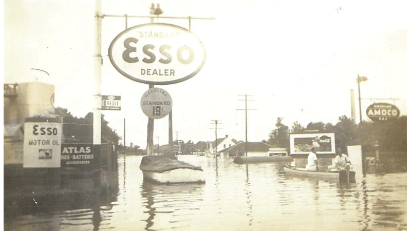
Some men were quick to realize the business possibilities of the situation and by Monday morning boats were available at almost every crossing. “Ferry” fares were standardized at 10 cents a crossing.
On Fourth Avenue, water stood deep in the Chevrolet showroom of B. B. H. Motor Co. and in Gulf Central Service Station. On Second Avenue, W. J. M. Holland Funeral Home was flooded and residents of the Virginia Apartments, across the street, were serviced by boats. The Norfolk Ledger Dispatch office and Sanford & Bracey Plumbing Co., occupying the lower floor of the Virginia Apartments, had several feet of water in them. The Home Telephone and Telegraph Co. telephone operators were rowed to work by boats.
Livery stables of F. E. Howell on Third Avenue and Roy Edwards on First Avenue were inundated. The livestock were safely removed.
The most spectacular rise of the waters occurred on lower East Second Avenue which leads to the Blackwater River bridge. The “Highway Esso Station,” “Tank Car Sinclair,” “Cavalier Gulf,” “Bob Coggsdale’s Texaco,” and “Franklin Amoco” service stations and Fred Edwards’ Grocery were flooded at various depths. The river came up as far as the W. E. Smith Buick Agency across the street from the old Knight Buggy factory building. Further up on Second Avenue, Jimmy Asteris’ J. & M. Grill and the R. P. Rawls & Son insurance agency were severely flooded.
Many residential areas were affected – especially on Saturday. Several residents had to leave their homes, such as John and Henry Hawa who abandoned their home on South Street. On Fourth Avenue, Mrs. J. H. Holland, Mr. and Mrs. Tall Jones, Mr. and Mrs. Walter Bradshaw, and Mrs. And Mrs. Vance Vaughan left their homes for higher ground – when the Fourth Avenue drainage ditch overflowed.
Occupants of houses on Broad Street and the residents of the “Pin Point” neighborhood, both bordering the Blackwater River near Franklin Wharf, were badly affected by the flooding. Houses in those areas were severely damaged. At least 75 people were evacuated and were made homeless. In Southampton County, two to three hundred people became homeless.
Mrs. T. B. Bell of Courtland, Southampton County Red Cross Chairman, secured the services of an American Red Cross disaster worker. Relief registration was setup in Boykins and Franklin.
CLYDE PARKER is a retired human resources manager for the former Franklin Equipment Co. and a member of the Southampton County Historical Society. His email address is magnolia101@charter.net.


