Two South Quays
Published 11:57 pm Monday, January 17, 2022
|
Getting your Trinity Audio player ready...
|
By Clyde Parker
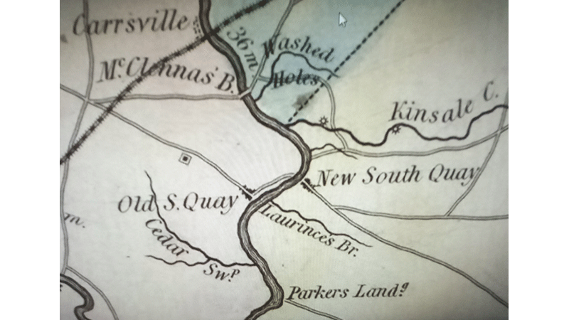
Actually, there are (or were) two South Quays in southeastern Virginia. The one that, in the present-day, comes to mind or is mostly known about, is the one that is located in the former Nansemond County (now the City of Suffolk) and referred to as “South Quay” and was – and its remains are – located on the EASTERN bank of the Blackwater River – near where the Route 189 drawbridge (now, being disassembled) is located. The other South Quay – the original one – (now referred to, historically, as “Old South Quay”) was on the WESTERN bank of the Blackwater River, but in Southampton County, Virginia, just about a couple of miles downriver from the present-day (New) South Quay
The (New) South Quay is where, during the American Civil War, in 1863, Confederate General James Longstreet and his men, going east to begin the siege of Suffolk, crossed the Blackwater River on pontoon bridges. At the end of that campaign, they retraced their steps, and came back by way of New South Quay, on the way to join General Robert E. Lee’s army for the invasion of Pennsylvania. On those two passages of confederate troops hangs all the significant history of the present-day (New) South Quay. It is, today, a subsiding roadside community, with just a few houses located near where the drawbridge was located. In recent years, South Quay has been best known as the place where the drawbridge on Route 189 spanned the Blackwater River.
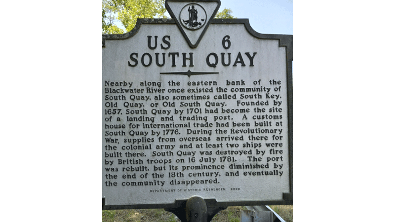
Old South Quay, located less than 2 miles downriver from (New) South Quay, is another matter.It was the South Quay of Virginia’s colonial days: Early references to it go back to 1657; by 1701, it was the site of a river landing; and, as early as 1712, it was a rendezvous for the Virginia Militia. In 1712, it was the site designated for a conference between Virginia Governor Alexander Spotswood and North Carolina Governor Thomas Pollock – to make plans for war against the native people, but Pollock did not attend.
By 1776, (Old) South Quay had developed into a trading hamlet and had become a port of entry with a customhouse. Warehouses and wharves were in existence there well before the revolution began and to them was added a shipyard. At the shipyard, in 1777, at least two vessels were built for Virginia forces – while Patrick Henry was governor. The ships drew 8 or 9 feet of water, and each carried about 18 small cannon. After being launched and manned at South Quay, those row galleys were used to defend North Carolina and Virginia waters from depredations by the British naval and land forces. One vessel, the “Caswell,” was named for Richard Caswell, then governor of North Carolina, in what would seem to be open flattery designed to induce his support for the building and equipping of both ships. The other was the “Washington,” commissioned shortly after “Caswell,” named for George Washington.
The careers of both galleys were brief; in 1779, Virginia Governor Thomas Jefferson complained that the two ships had proven to be ineffective for the applied purposes
As the Revolutionary War unfolded, (Old) South Quay was one of the few posts left open for the patriots’ use. It and other points when approached by ships through the inlets of the Outer Banks of North Carolina, though dangerously located, were not completely blockaded by the British Navy as were the major ports of Wilmington and Norfolk and the harbors to the north of them. Governor Jefferson was intent on keeping open his backdoor waterway through North Carolina to Virginia. He well-knew how remote and unsuitable South Quay, with its long and slow approach from the sea, was for those shipments that did arrive, and how laborious transport was by wagon-train over the 25 miles of road to Suffolk which had been called the chief depot for military supplies in Virginia during the late months of the war. Admittedly, South Quay was inconvenient for trade, he said, but it had the advantage of being hard for the enemy to get at.
However, when the British closed Chesapeake Bay, in 1781, the Blackwater River port of (Old) South Quay, accessible, by way of the Chowan River, from Albemarle Sound, became an important supply center for the Southern American Armies, so much so that the British finally sought it out and destroyed it, by fire. Nothing of any significance ever rose from the ashes – at that site.
(Old) South Quay is now merely an indefinable spot of land on the Blackwater River, where many things happened, whose traces have long since disappeared. No buildings are near the ancient landing place and no signs of man’s activities are in evidence except Highway 189, which skirts close to the riverbank, and the well-tilled fields beyond it. No noises are heard except the hum of passing automobiles and the clatter of distant farm machinery. It is a peaceful spot, with no vestige of the transactions and events it once witnessed. A historical marker, by the Virginia Department of Historic Resources, is located between the highway and the river.
SOURCES:
• “Old South Quay in Southampton County,” by John Crump Parker
• Southampton County Historical Society
• The Virginia Magazine of History and Biography
CLYDE PARKER is a retired human resources manager for the former Franklin Equipment Co. and a member of the Southampton County Historical Society. His email address is magnolia101@charter.net.


