Don’t put down your guard now
Published 11:35 pm Tuesday, September 11, 2018
ISLE OF WIGHT
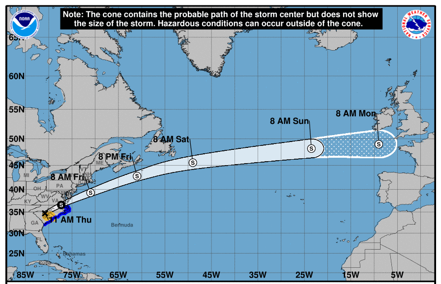
As of the 5 p.m. National Hurricane Center forecast update a hurricane warning and a storm surge warning has been issued from Duck, North Carolina, and the Albemarle and Pamlico Sounds to South Santee River, South Carolina. Hurricane warning means hurricane force (74-plus mph) winds are possible in the next 36 hours. A tropical storm warning has been issued from the VA/NC boarder to Cape Charles Light, Virginia, and for the Chesapeake Bay South of New Point Comfort. A tropical storm warning means tropical force (39-plus mph) winds are possible in the next 48 hours.
While the last couple of updates have trended more in our favor, now is not the time to put down your guard. Florence remains an extremely dangerous storm and it is still very likely that our area will see at least tropical storm impacts. The National Weather Service has begun to provide more local specific forecast impacts this morning. Uncertainties in the forecast still exist, changes in the forecast track will greatly change the impacts felt across the local area. Based on information from the NHC and National Weather Service (NWS):
Strength/size — Florence is currently a CAT4 (140 mph.) Continued strengthening over the next 24-36 hours is likely through Wednesday. Florence is expected to slow down considerably by late Thursday into Friday. Florence is forecast to still be a strong CAT4 storm when she makes landfall. Florence’s wind fields have continued to grow — tropical force winds now extend hurricane force winds up to 175 miles and hurricane force winds extend 60 miles from her center.
Forecast track — Overall the models are coming more into agreement and the confidence in the forecast prior to landfall is growing. The NHC is currently looking at highest hurricane possibility between Jacksonville, North Carolina, and Wilmington, North Carolina. We will likely continue to see fluctuations in Florence’s forecast track. Don’t focus too much on where the center line of the Florence — the actual storm track could occur anywhere within the NCH forecast error cone. The NHC forecast is still expecting Florence to stall soon after making landfall — it is currently forecast to remain almost stationary for more than 24 hours before continuing a more west track into North Carolina. The last couple of forecast updates have kept the forecast track south of Virginia. However, because of the size of the storm and the remaining uncertainty in the track once comes on shore, we still have the chance of seeing at least tropical storm force (39-plus mph) and hurricane force (74-plus mph) winds and heavy rain.
Rainfall — NWS is currently forecasting 6”-10” for IOW. Overall, Florence is expected to produce total rainfall accumulations of 4”-12” inches with isolated maximums of 15”-20-plus” over portions of North Carolina, Virginia and northern South Carolina through the weekend. Dangerous flash flooding and flooding may occur Friday through the weekend.
Winds — NHC forecast has not changed the wind chances for Hampton Roads significantly from the last update. Currently forecasting:
• 63 percent chance of tropical force winds (39-plus mph; down from 66 percent)
• 19 percent chance of strong tropical force winds (58-plus mph; down from 24 percent)
• 10 percent chance of hurricane force winds (74-plus mph; down from 10 percent)
Based on NWS hourly forecast information, IOW will likely see winds start to increase mid-day Thursday. While timing for winds is most likely now Thursday evening, it is possible that winds could begin as early as Thursday morning. Sustained will likely be at least in the high 20s to low 30s before dawn on Friday. Friday through Saturday late afternoon sustained winds are forecast to be at least in the low 30s with gust nearing 50 mph. Winds in the NWS is currently forecasting winds to begin to taper off Saturday night. Actual wind timing and extent will be highly dependent on the actual track of Florence.
Inland Flooding— NWS still has IOW in the moderate risk level for inland flooding. Flooding in low lying areas and ditch overflow will also likely be an issue — especially on the back roads.
Forecast levels for the Blackwater are for the major flood level. The forecast currently has the Blackwater at about 19’ on Saturday (noon) and it continue to rise to over 20’ by Tuesday (9/18 at midnight.) The current Blackwater forecast only goes through noon on Sept. 18, but it doesn’t look like it will have crested by then.
As a frame of reference, Floyd crested at about 25’ and the October 2006 crested at about 22’. Blackwater River levels will be highly dependent on the amount of rain we see in the Blackwater River Basin — the forecast levels do not yet factor in the fact that the rain forecast for the state has gone down considerably today.
We may see the forecast levels reduced over the next several days if the current Florence forecast track holds. That said, now is not the time to put down your guard, keep a close eye on the local TV/Radio updates, in case these high water levels occur.
Storm Surge/Evacuation — The NWS is currently forecasting for less than 3’ of storm surge along the IOW coast line. A storm surge warning has been issued from Duck NC and the Albemarle and Pamlico Sounds to South Santee River. As of 7 o’clock Tuesday, no storm surge watches or warnings have been issued for Virginia. Storm surge-related flooding depends on the relative timing of the surge and the tidal cycle, and can vary greatly over short distances.
Governor issued an evacuation notice of Storm Surge Evacuation Zone A last night effective at 8 o’clock this morning. In IOW county, a general description of Zone A would be property that sits on or near all of the county’s coast line (e.g. along the James River, Pagan River, and Chuckatuck Creek). You can determine if a property is in a Storm Surge Evacuation Zone by entering an address at the KnowYourZone website (www.knowyourzoneva.org). Additional information about KnowYourZone is available on the county’s homepage (http://www.co.isle-of-wight.va.us). Individuals with property in Zone A should monitor local TV/Radio for updates on storm surge watches and warnings closely.
State of Emergency — The County declared a State of Emergency as of 6 p.m. on Monday.
Continue to monitor local TV/Radio closely. Follow the County’s Facebook page (Isle of Wight County Virginia) for more frequent updates.