In the land of yellow rock
Published 11:58 am Saturday, January 16, 2016
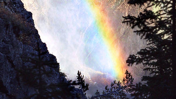
Rainbow in the mist seen from Uncle Tom’s Trail. — SUBMITTED | ARCHIE HOWELL
by James D. Howell
I leave the cabin early; I plan a long day. I’m going to do a short back country hike, a loop really, and wind up on the south rim of the Yellowstone canyon just east of Artist Point. The weather holds with clear blue skies. It’s late in the year — not the best time for pictures of Yellowstone Falls, but I’m here and I’m going to do the hike and take some pictures.
I leave the Old Faithful grounds and cross the Continental Divide west of Yellowstone Lake. All the creeks and rivers beyond this point flow to the east/north; those behind me flow west. The park straddles the divide almost equally.
Yellowstone Lake dominates geological features of the southeast quarter of the park. Hunters and trappers knew of the lake long before its park status, but during American expansion to the west, it became well documented. It covers a little over 130 square miles; it’s close to 400 feet at its deepest; it is fed by rain, snow and geothermal springs. The last volcanic eruption occurred here at the West Thumb.
It is also the main water source for the Yellowstone River. I take little time along the lake’s shore. My main interest today is the hike; at the Lake Village, I head north.
I’ve picked a circular hike starting at the parking lot for the lower falls; the trail will take me through some woods, across an open field, and will join the canyon just downstream of Artist Point. From there, I’ll hike the rim trail back to this parking spot.
It’s an easy saunter down the shallow incline to the field. I see a coyote, the park clown, searching for food in the grass. It’s fun to watch it listen, jump, listen and jump again. I don’t think that find was successful. Close by the trail in the next woodsy spot are bubbling mud pots. This geologic feature is prevalent throughout the park. I’m careful to not step too close to the rim; it’s always a guess as to what will support my weight. I’ll see no one else on this part of my hike; help is a long way off should the crusty surface give way.
I take a break in a shady glen before starting the climb to the canyon rim. Grouse and other birds flutter and twitter in the undergrowth. They go about their day, paying little attention to my presence.
The top of my trail merges with the rim trail east of Artist Point. I take another short breather and pause at the canyon before me. Bright, sunlit rugged walls of yellow rise sharply either side of the Yellowstone River. The color comes from sulphur, found abundantly where volcanic activity occurs. I set the tripod, and record the view.
A short walk later, I again set the tripod and record the view of Yellowstone Falls from Artist Point. Countless others before me have done the same. No doubt, countless others will follow. It is an awesome sight. Steep, bright yellow walls, sporadic tree lines and the spectacle of the falls themselves is a sight guaranteed to make a person feel small and thankful to have had the experience. I stand and try to take it all in. I leave the view reluctantly.
It’s about a mile back to my car at the falls lot. Just off the lot is a winding trail to the river bottom, if I have enough time and energy to do it. It’s named “Uncle Tom’s Trail” for the man that made it and escorted visitors down to the river and back. The warning sign is intimidating. It is, after all, 8,000 feet elevation here and I’m already a little tired. It’s 328 steps to the bottom; this is once in a lifetime and I press on.
I decide to follow the sign’s suggestion and rest often. I use those times to look out and up at my surroundings. The falls can be heard approaching the lower steps and a larger rest area has a wonderful view. I take extra time, set up the tripod and relish the moment. There’s a nice prismatic rainbow across the mist today; the breeze of the water cools my face. The chatter of the few others on this trail is excited and happy. I descend to the lowest level; I’m surprised to learn that the best photo opportunity is from the rest spot on the steps.
The climb back to the parking lot is anti-climactic; I retrieve my car and drive back to the cabin in early evening. It’s a long day and a fitting end to my stay in the land of the yellow rock.
JAMES D. “ARCHIE” HOWELL is a Southampton County native and 1955 graduate of Franklin High School. He can be reached at archiepix@kingwoodcable.com.


