Paint pots and spear points
Published 2:05 pm Saturday, January 9, 2016
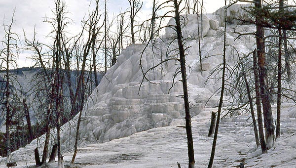
Limestone overtakes trees in a new area.
by James D. Howell
I’m headed to the north entrance to Yellowstone National Park; it’ll be a stop-and-go drive via Madison and the Norris settlement. I’ve allotted a day for the trip and return to my cabin.
I drive along the Firehole River to Madison. The transition from the upper geyser basin to the lower is marked by numerous geysers, mud pots and steam vents. Everywhere, on this cold morning, steam rises and evaporates into the clear, dry air. Near vistas and distant tree lines are outlined with rising misty steam clouds.
About halfway, the Norris Geyser Basin has well-marked walkways and paths. These are different volcanic features, seemingly a little more open and docile than those along the Firehole. Large pools of hot water with mineral-crusted edges dot the basin’s flat surface. It requires a short walk for most of the features; a sulfurous smell is prevalent this morning.
This land became a national park in 1872; visitors, prospectors and hunters used the park land routinely. In the rest of the American west, Indian resettlement into designated zones or reservations were still very much in progress. Battles were still being fought, and were fairly well recorded by the media of the day.
One of the last campaigns was to remove the Nez Perce people from Oregon to a reservation in Idaho. The Indians resisted and a hit-and-run battle took place across the width of this park. Encounters with visitors and others occurred, some with deadly results. Chief Joseph became something of a national figure because of the extensive newspaper coverage. He led his tribe almost straight across the park, crossing generally where Norris is today.
Just past Norris, the road climbs noticeably and I am conscious of red-tipped markers alongside the road, about six feet high.
It doesn’t take a genius to know they are snow markers, that indicate safe boundaries for winter travel and/or snow plowing operations. I have to let that sink in for a while. I know winter is not far away in this park.
I also know that just off the road to the east are obsidian cliffs, used for thousands of years by native Indians to make spear and arrow points.
The large deposit of the glass-like rock provided trade goods as well as local tools for daily use; knives and scrapers could easily be made. My friends in northern Arizona can find small arrow points that may have been mined from these cliffs.
There are several well worked mines along this mountain edge.
I continue under blue skies to Mammoth Hot Springs, with its visitors center, just inside the northernmost entry to the park. Very few vehicles are in the center parking lot. I find that there are a few pull-off spots from the main road and a considerable number of walkways, both raised boardwalks and well worn paths.
This area was the original entry to the park. It’s also the location of Fort Yellowstone, built to manage the parks resources. Being the first, authorities had to develop a plan for facilities and visitors. Management moved to the National Park Service when it became established in 1918. Many of the original buildings (and policies) remain today. The historic district is just down the street a bit. Today, it remains the park headquarters and a main provisioning center for visitors, with a hotel, restaurant, fuel, grocery and camping supplies.
I begin my tour just south of the hotel and visitors buildings, at the main terrace. It’s huge. row after row after step after step of multi-colored limestone. The main terrace area is about a half mile across; just to the south is another half mile circular area with different terracing — more recent, with entwined trees. I walk the extensive boardwalk and take pictures.
These formations are caused by water from rain and snow slowly sinking into the earth through fissures. It becomes heated by underlying magma and is forced back to the surface through other fissures.
Along the way, it picks up dissolved sulfur and other minerals, along with enough carbon dioxide to make a mildly acidic solution.
Minerals arrive at the surface, where the water evaporates and the residue forms these shelves of mostly limestone. Colors develop from various minerals and algae that live in the hot pools. The shelves and pools are constantly changing. Some years, there is very little flow in some parts of the terraces; other years, parts deteriorate and collapse. It’s Mother Nature at Her finest.
I investigate a small part of the whole. There just isn’t time to do it all. I return to my cabin late in the day, tired, but thrilled at the natural beauty of this place.
JAMES D. “ARCHIE” HOWELL is a Southampton County native and 1955 graduate of Franklin High School. He can be reached at archiepix@kingwoodcable.com.