Hurricane huntin’
Published 9:54 am Friday, November 7, 2014
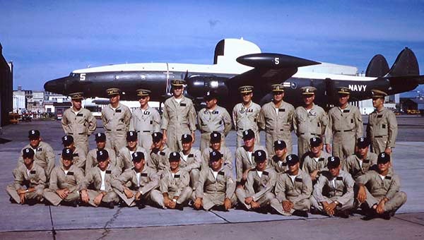
Archie Howell’s crew and aircraft on the ramp in Jacksonville, Florida. Archie is in the back row — the fourth from the right. — SUBMITTED
by Archie Howell
I dress in a daze. It’s an automatic chore, thankfully. Lights from my room spill into tropical darkness through open windows. I complete the job and join other crew members in the back of our duty truck for a trip to the mess hall. We encounter very little movement of people or vehicles en route. Our usual good-natured bantering is missing.
The remainder of our flight crew has already arrived and we exchange brief greetings. No one is moving or thinking quickly just yet. Mess cooks have prepared breakfast for us this morning; nothing else is available on the base. Part of our detachment includes mess cooks and support personnel. Spirits grow more awake with coffee, food and conversation, and we check on the aircraft’s condition and preparation. Our plane captain completed routine maintenance and fueled the aircraft yesterday for today’s mission.
We’re airborne just after 3 a.m.; it’ll take us about three and a half hours to get to the latest suspicious area, about 200 miles east of Martinique Island; we’ll get there just after daybreak. We’ll be able to see fairly well then and will have time to track anything we discover.
We’re heavy. All fuel tanks are full; our weather specialists are on board, and we have a full complement of weather buoys to help record data for interpretation. We have food and water for a sustained mission.
Lift off is normal into the darkness; we’re well aware of the additional load. Early morning coolness and sea level pressures help the four engines crank out the power. As soon as practical, we get the landing gear up; around 300 feet, we level off and begin to bring up the flaps at a few degrees at a time. Power is reduced to climb values as speed increases, and a few more degrees of flaps are retracted. We have no fear of running into anything out here; it’s all open water and we can steer around islands. Airspeed is far more important than altitude at this time.
We split the distance between Vieques and Culebra islands, and continue the climb to 2000 feet. That’s as high as we will get for the next 6 hours. International flight agreements let us navigate freely at or below 2000 feet under visual flight rules. We can turn, descend or climb as necessary. Most of our flights use these rules.
When clear of Vieques, we turn south east, skirt St. Croix, in the American Virgin Islands, and head for Montserrat. The suspicious area is some 200 miles to the east of Martinique and St. Lucia. Most on board, except for necessary crew, are asleep. We’ll all have to be awake and alert soon enough.
We can follow the lights of islands in the distance as we pass in darkness. Our radar operator can fix our position for navigation; there are few radio navigation facilities in this part of the world. As we leave the island chain, we’ll use dead reckoning for navigation, with Loran (Long Range Navigation) receivers for accurate fixes. Loran has been a mainstay for shipboard and aircraft navigation for several years. Mostly gone are the celestial sextants that were my forte during my first sea duty. I don’t miss them.
We are careful to skirt islands as we pass; even these missions comply with international territorial rights. If an airport tower or control area is operating, we check in, declare our intentions, and leave on good terms. We do not fly over islands.
Somewhere past Guadaloupe Island our crew begins to awaken, sip on some hot coffee and prepare the aircraft for storm searching. Trade winds blow from the east in these tropics. A sure sign of cyclonic activity is the presence of a west wind. We are the first aircraft to investigate this disturbance, and we’ll all be looking for whitecaps blowing from the west, indicating a closed circulation.
Long-range radar is one of the main advantages of the Connie. Our radar operator has no problem identifying a large area of clouds and rain in the distance. We’re here.
Radar cannot find a defined eye wall, so we fly a search pattern for wind direction and speed. Our weather persons check sea surface temperature and pressure. We do locate a definite west wind and can see the characteristic swirl of clouds around a fairly large central area. A tropical storm is declared, its position double checked and radioed to the National Hurricane Center. Our job here is finished.
We climb to 10,000 feet, turn on the air conditioners and enjoy some cool air en route back to Rosy Roads. We will have several more days with this system; the Hurricane Center designates it Tropical Storm Beulah.
JAMES D. “ARCHIE” HOWELL is a Southampton County native and 1955 graduate of Franklin High School. He can be reached at archiepix@kingwoodcable.com.


