GPS keeps farmers’ crops in line
Published 11:15 am Wednesday, June 5, 2013
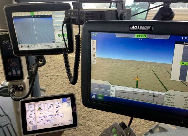
This is an example of a GPS unit within a tractor’s cab. The farmer can use this to accurately guide him in preparing or ripping the land, planting seed or adding fertilizer. — SUBMITTED/JAMES RIVER EQUIPMENT
BY STEPHEN H. COWLES/STAFF WRITER
Playback58@gmail.com
COURTLAND—The same Global Positioning System used by automobile drivers can be equally practical for farmers, such as Ray Davis. He farms an area north of Highway 35 between Sebrell and Courtland.
“We just purchased it this year in the spring, and we’ve been running our sprayer for awhile, prior to buying the entire system for all the tractors,” said Davis, 59. “The main tractors we’re running do all the planting and everything. It works real well.”
A farmer for 40 years, Davis likes how the system keeps track of planting and adding applications for seed. This means he doesn’t have to concentrate quite so hard on making sure “everything’s running as it needs to be.”
Describing himself as “kind of old school,” when it comes to his profession, Davis still used row markers this planting season to compare how well the GPS served him.
Suffice to say he’s keeping the technology.
“It’ll definitely run a straight row, and that’s one thing farmers like,” Davis said. “Planting season is always stressful, and if you don’t start right, you can’t end up right.”
“It’s not cheap, but I sleep better at night,” he added with a laugh. “We enjoy it”
Now that Davis is more comfortable with the GPS, he’s beginning to use more of its potential, including the recording of harvest data for future reference, fertilizer applications and showing weak areas in fields.
“It’s a tool that has more capabilities than we’ll ever use,” said Davis.
Guidance, yield mapping and controlled application of seed and fertilizer can all be done through GPS, said Matt Brantley, a precision ag manager for James River Equipment. He works across all dealerships in helping farmers get what they need.
He’s also involved with Integrated Solutions, a department that merges technology with farm machinery through training and marketing. He can teach farmers how to apply the GPS tools to the desired tasks.
“We also do soil management zones,” Brantley said, explaining a boundary can be created in a field with GPS and broken down into management zones defined by soil type, rather than treating the entire field as one. This allows each zone to perform at its full potential.
GPS enabled yield mapping allows information to be retrieved by a combine. The data can then be spatially sorted by the client, farm, and field. This information helps to build a foundation that future farm management decisions can be based on.
Guidance systems and section control are usually the first things a farmer needs. The accuracy from GPS allows field operations to be performed more efficiently and with less stress on the operator, Brantley said.
There are a lot of different accuracy levels, he added, ranging in price from $15,000 to $32,000, with an average of $22,000.
“The precision guidance has been available for a few years now, but it is much more widely used now than it was five years ago,” said Chris Drake, extension agent for Southampton County. “It is fast becoming a common practice for farmers to have some sort of GPS-based guidance system on their tractors, sprayers and combines.”
He added that the technology has improved remarkably well in the past few years.
“For example, if we are planting on rows spaced at 36 inches apart, the tractor and planter can be as accurate as less than one inch from the desired spacing,” Drake said.
Farmers using new systems based on Real Time Kinematics can get accuracy that repeats pass to pass, he said, adding that the lines can even be put into a flash drive and use for spraying, harvesting and so forth.
“Basically, you can go right back over the same tracks next week or next year,” said Drake.
“We provide GPS technology in the local area,” said Milton Vaughn with Crop Production Services. That company is owned by Agrium Advanced Technologies. Vaughan also does resale for Trimble, which according to its website, combines positioning via GPS, laser or optical technologies with application software and wireless communications to offer solutions for commercial uses in agriculture, construction or engineering.
Vaughan said he’s been with CPS for 16 years, and since then the accuracy for planting with GPS has gone from within six to eight inches down to one inch for most makes and models of farm equipment.
“’Mom, no hands,’” the dealer said as a way of comparing it to cruise control in a car.
The technology works not just for planters, but also sprayers, he added.
In earlier years, Vaughan said, the price could be $50,000, depending on the tractor, but now can range from $20,000 to $25,000, again depending on make, model and year.